

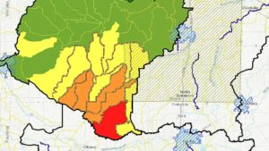
The pressure is on western Ohio farmers to cut down on fertilizer use and nutrient run-off. Recently published maps of the Lower Maumee Watershed pinpoint areas where nutrient runoff (such as phosphorus or fertilizer) is highly concentrated, with the worst areas, primarily near farms, is south and west of Toledo.
Last summer marked the third largest algal bloom outbreak in Lake Erie’s history. Excessive algal blooms are a major environmental threat to Lake Erie and the surrounding communities, and many worry about the impact these blooms could have on local ecosystems, businesses, drinking water and economies.
Although Lucas County and the city of Toledo have reportedly spent millions to combat toxic runoff, environmentalists are using the maps to call on farmers to do more.
You can look at the map yourself here.