With advanced planning and the right tools, the Loop is an easy adventure!
Story & photos by Tom & Brenda Lahey
America’s Great Loop is one of the world’s most cruised routes. It is roughly 6,000 miles of inland waterways, bays, rivers, canals, lakes and coastal passages. The route is well-documented and widely traveled. For some, the idea of embarking on this epic voyage is intimidating, but having completed two circuits of the Great Loop, we can assure you that it’s easy. Each year, over 250 boats complete the Loop. In 2025, the America’s Great Loop Cruisers’ Association (AGLCA) fleet T-shirt listed 458 boats actively Looping. You will have plenty of people to follow!
With the right charts, cruising guides, electronics and insight from the AGLCA and other Loopers, navigating the Great Loop route is very straightforward.
What you need
Historically, paper charts published by NOAA (the National Oceanic and Atmospheric Administration) were the go-to tool for navigation. In January 2025, NOAA stopped publishing paper charts. You can still obtain them in PDF format or as printed copies from third-party publishers. However, due to frequent updates and changing conditions, paper charts can be unreliable.
The gold standard today is a chartplotter, which is an electronic map that tracks your current position using the GPS satellite system. Chartplotters update maps through memory cards or internet feeds. They allow regular updates and eliminate the need to manually plot your position. Chartplotters also provide augmented information, such as bridge heights and schedules, marina information, anchorages and, in some cases, detailed colored depth charts showing optimum channels. Some allow boaters to contribute important information in real time, such as missing markers, shoals and other hazards.
The most popular manufacturers for chartplotters are Garmin, Raymarine, Simrad and Furuno. Some apps can be used on tablets and laptop computers. The most popular of these are from Navionics, OpenCPN, AquaMaps, Argo and iNavX.
It’s important to understand how to use your chartplotter and ensure that the navigation information is updated regularly. Also, no chart or chartplotter replaces understanding basic navigation and how to read navigational markers. Just like the Nav system in your car, the view through your windshield is reality. Chartplotters, like automotive GPSs, are really just like video games!
A discussion of electronic chartplotters would not be complete without a mention of Bob423 ICW Tracks. Robert Sherer and a group of regular cruisers create highly accurate, up-to-date GPS tracks for navigating the Atlantic Intracoastal Waterway (ICW). These tracks are widely used by boaters to avoid shoaling and groundings, providing a safe, tested path from Norfolk, Virginia, to Florida. You can learn about Bob’s Tracks at bobicw.blogspot.com.
Guides, books and seminars
Waterway Guides and Quimby’s Cruising Guides are the most popular guidebooks used by Loopers. These provide detailed information on marinas, bridges, locks, anchorages, and things to see and do in the many towns and cities along the route.
The AGLCA offers seminars and online resources to members through its events and on the GreatLoop.org website. There are also several books, YouTube videos and podcasts that provide a wealth of information on navigating the Loop.
Loopers helping Loopers
Another excellent resource when navigating is to reach out to locals for their knowledge and experience. Many marinas offer briefings to
Loopers with tips on navigation and weather. Most dockhands can help you find local restaurants and businesses to resupply or obtain assistance.
The AGLCA has a program called Harbor Hosts. These are members who live near marinas and offer assistance and advice to Loopers. If you have a special package, need a ride for resupply, or need a ride to the local clinic or airport, most Harbor Hosts are more than happy to assist. Brenda and I are Harbor Hosts in Palm Coast, Florida. We’ve received packages and given rides to airports, car rentals, doctors and even vets. We help with repairs and provide rides for resupply. You can find Harbor Hosts on the AGLCA member directory.
As you travel around the Loop, you will encounter other boaters with knowledge of an area or part of the route. Perhaps they are Gold or Platinum Loopers who have traveled that route. Chatting at the dock and docktail gatherings is a great way to network and gain valuable insights.
In areas where charts are not clear or there are reports of recent shoaling or hazards, you can utilize your TowBoatUS or SeaTow membership to reach out to local captains with questions. This is a valuable addition to your membership that many do not utilize.
Follow the bread crumbs
While not quite bread crumbs, navigational aids and charts have marks that will guide you along the route.
The ICW can be a confusing labyrinth of connecting channels and shipping lanes, where navigational aids switch from red on the right to red on the left. A handy thing to remember is that all along the ICW, day markers and buoys will have a small, reflective, yellow square or triangle symbol indicating the preferred ICW route. Looking for these markers is an easy way to ensure you are on the main ICW route.
Another rule of thumb is that the orange triangle always points to the “heart of the country” or inland when in the ICW. Remember, however, that when you enter shipping channels, the rule changes to “red right returning from sea.” In these areas, you may see a yellow triangle on a green square day marker and vice versa. Whenever you reach the intersection of channels, it’s important to verify which rule the markers are following.
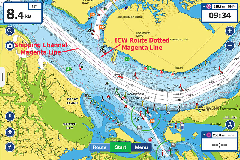
Most charts, especially those along the ICW and major boating routes, will show a magenta line that tracks the typical route of the ICW or common boating channels. Remember, this is a basic guide to the route; it’s not a navigation path. Frequently, the magenta line will cross shoals, dry land or vanish from charts completely! We’ve seen boaters who follow the “magenta line” and end up grounded. Be sure you understand your route, read the markers, and research notices to mariners from the Coast Guard and other agencies.
Platinum pointers
Plan your day in advance and review the route on your chartplotter. Make notes on tricky spots. Most Loopers average 30-90 miles per day. We pre-plot our day on our chartplotter so that we have a clear path to follow.
Write down the heights and opening times of bridges and locks along your route for the day. Time your arrival so that you don’t have to wait extended periods. We put small Post-It notes on our helm with information about the bridges, locks and marinas.
Check tides and currents. The depth and current can heavily affect your passage in many areas. Time your passage for favorable tide windows when possible. We use the real-time current and tide information on Navionics.
Watch the weather along your route. Check the forecast and wind/wave predictions for the entire day and overnight if anchoring. We use apps like Windy and Predict Wind to see wind and wave forecasts for the next several days.
Navigating America’s Great Loop is easy if you prepare and develop good planning skills. Having up-to-date chart data, as well as tide and weather information will make planning your daily cruises easy and will ensure that you have enjoyable days on the water. Do that, and navigation on the Great Loop becomes not just manageable but genuinely enjoyable.
Top image: Navionics chart with ICW and shipping channels marked
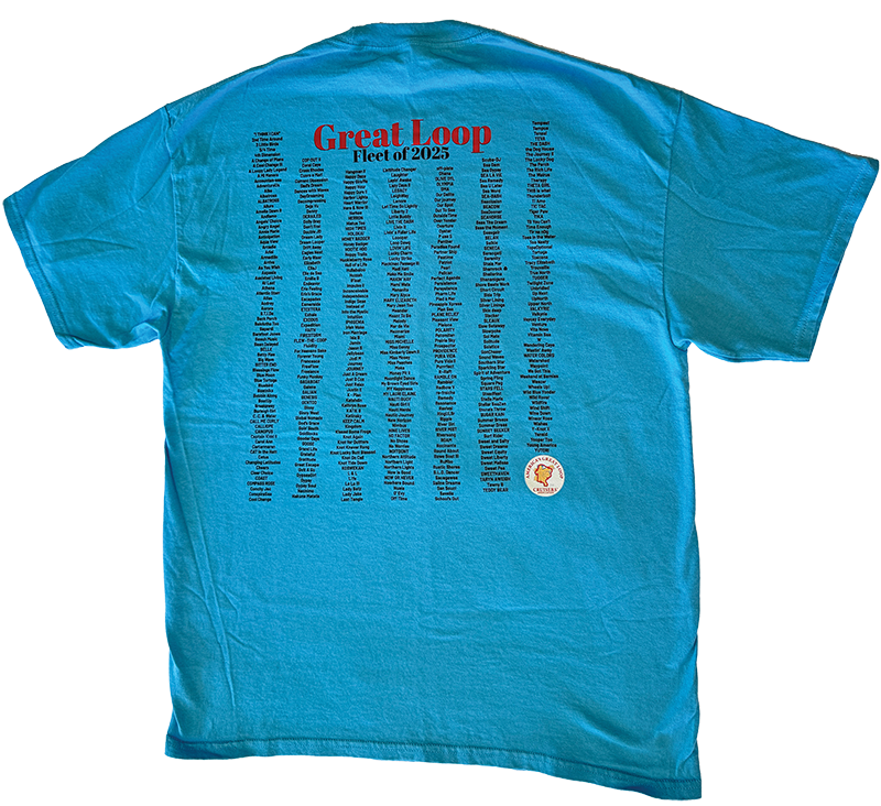
Great Loop 2025 fleet T-shirt with 458 boats
Red ICW buoy, Mile Marker 0, Norfolk, VA
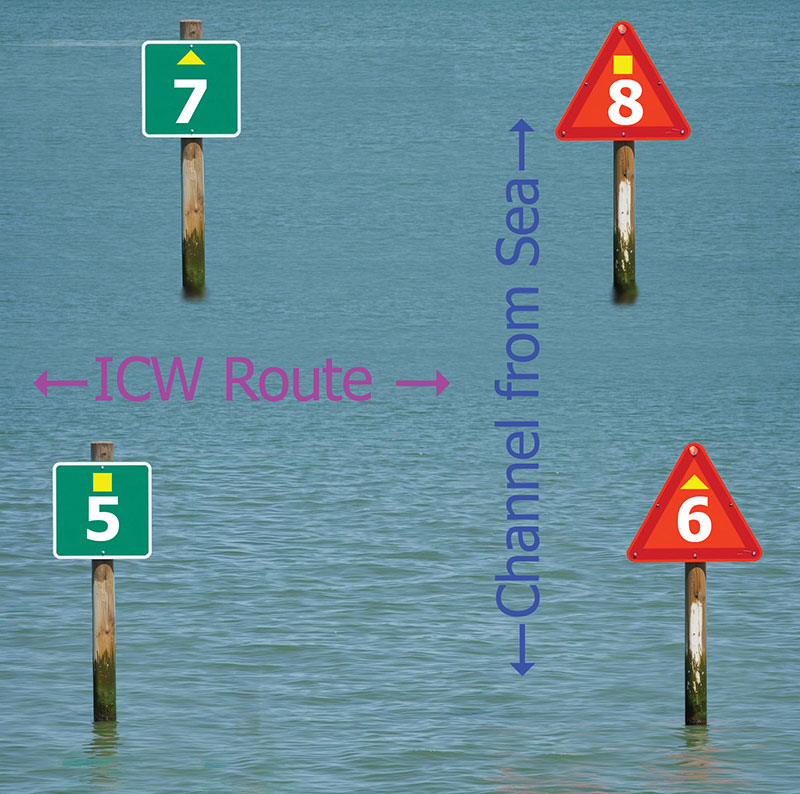
Illustration of flipped ICW markers
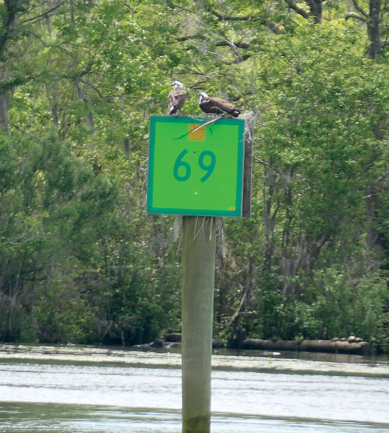
Green ICW day marker with ospreys, Waccamaw River, SC
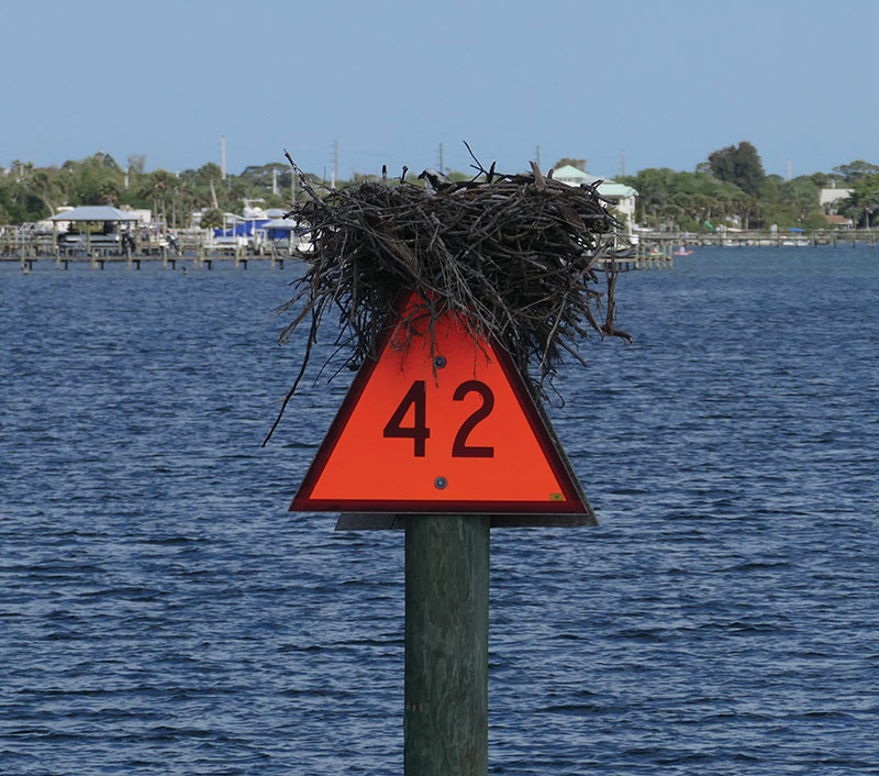
Marker obstructed by a nest, Halifax Rive, Daytona, FL